When the Corps of Discovery and British fur traders first pioneered the Pacific Northwest, they remarked upon the settler-friendly Willamette Valley. The story that followed is familiar to most. Settlers from the East motivated by cheap, fertile, temperate land and notions of manifest destiny spilled across the continent along the various Oregon trails to stake a claim in what early 19th century American republicans could have only described as a paradise. What they did not know was that lurking just beneath the surface of their newfound nirvana was a geologic clock counting down to the eventual destruction of much of what they and their descendants would create.
The Cascadia subduction zone extends for roughly seven hundred miles off the coast of northern California, Oregon, Washington, and Vancouver Island, Canada. The zone represents the border between the North America plate–encompassing virtually all of North America and extending as far east as the Azores–and the Juan de Fuca plate, a much smaller plate off the coast of the Pacific Northwest. Over the course of hundreds of millions of years, the Juan de Fuca plate has been sliding underneath the North America plate. Usually, this occurs with little to no human consequence. But every so often, pent-up energy along the Cascadia fault line and hundreds of others like it can release all at once and cause earthquakes of varying intensity and frequency. In Cascadia’s case, the results will be dramatic.
According to seismologists’ best estimates, if just part of the Cascadia subduction zone gives way at once, the result will be an earthquake between magnitude 8.0 and 8.6. If the entire zone slips, the results are even more dire: a quake between magnitude 8.7 and 9.2. For comparison, the 1994 Northridge quake that struck Los Angeles was (only) magnitude 6.7, killing 54 people and causing $20 billion in damage.
Compounding the effects in the Cascadia case is the nature of a potential quake. Unlike most California quakes, the epicenter will be in the Pacific Ocean. The release will displace vast amounts of water very quickly, causing a massive tsunami that will devastate the northwest coast and potentially even Japan. FEMA estimates that as many as 13,000 will die and another 27,000 injured in the ensuing quake and wave. A million more will become homeless and countless millions more may be without food, water, and electricity for weeks and even months.
The scale of destruction will be unlike anything the United States has ever seen. Fortunately, cities and towns along the Pacific coast and in the affected inland zones have started to take precautions, such as tsunami evacuation routes, early warning systems, and infrastructure retrofitting. These measures are still in their infancy, but they–as well as increased public awareness regarding what to do during and after a quake–will save untold lives when (not if) “the big one” strikes.
This would make those who studied the Cascadia subduction zone potential lifesavers–literally. Yet seismologists alone could not piece together the imminent danger of the Cascadia subduction zone. To truly understand the threat potential, an international cross-disciplinary effort that included dendrochronology, anthropology, and even history was needed. The resulting research itself is a fine argument for a liberal arts education, but it’s also a compelling research story and a testament to diligent work.
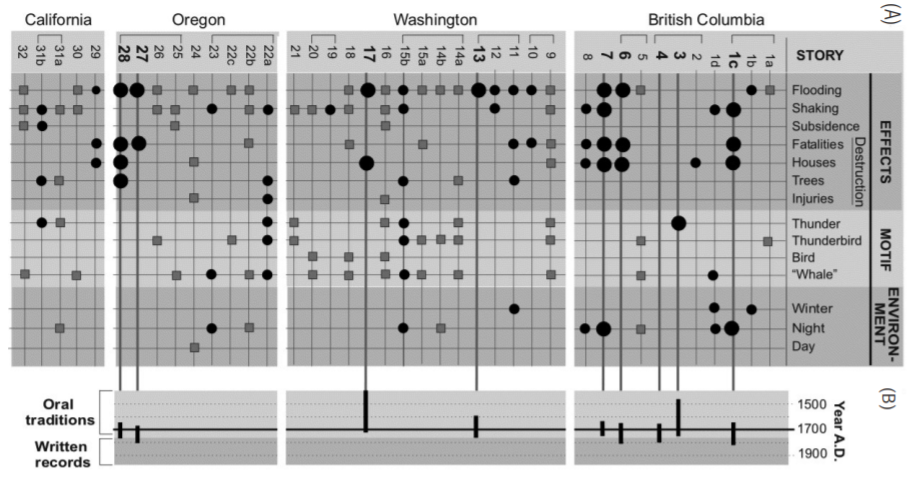
The earliest recorded evidence of a possible threat came in 1864, when early Washington territory resident James Swan recorded in his diary an interaction he had with a member of the local Makah tribe, Billy Balch. According to Balch, his tribe–which lived in the area around Neah Bay near the tip of Washington’s Olympic Peninsula–had passed down through oral tradition a story from the not-so-distant past where “the water receded and left Neah Bay dry for four days and became very warm. It then rose again without any swell or waves and submerged the whole of the cape and in fact the whole country except the mountains.” According to Balch via Swan, many villagers died and canoes lifted to the treetops. Some survived by packing their effects into canoes and riding the wave. Swan noted the story in his diary, but did not seem to be alarmed. Perhaps he did not see the danger that could be associated with his new home. Perhaps he dismissed the oral tradition as merely a native folktale and certainly nothing he, a White man embodying destiny manifested, should fear.
One hundred years later, Chief Louis Nookmis of the British Columbia-area Huu-ay-aht First Nation related a similar story in 1964. According to his tribal history, Nookmis described that “it was at nighttime that the land shook.” According to another tradition, villagers “sank at once, were all drowned; not one survived.” Both Nookmis and Balch’s stories seem to suggest that the Pacific Northwest was vulnerable to earthquakes and tsunamis. Yet despite these independently recorded, vivid descriptions of what were clearly devastating tsunamis, the accounts went largely ignored. Ignored, that is, until seismologists started looking for them.
Seismologists had long known about the infamous Ring of Fire, a network of earthquake and volcanic hotspots that ring the Pacific. They also knew that Cascadia fit within the ring, but were not sure if the fault line was still active. The 1980 eruption of Mt. Saint Helens suggested there was still activity in the area, but as far as dramatic subduction activity, many assumed the fault line was dormant. After all, there had been no known major earthquakes in hundreds of years. Major quakes had struck elsewhere–Chile, Japan, Mexico–multiple times within recent memory.
Other scientists began searching for other clues. Geologist Brian Atwater first started looking into the possibility of a massive seismic event in the 1980s. In 1986, Atwater was digging along the beach of Neah Bay (the same from Balch’s account) when he discovered preserved arrowgrass under a top layer of sand. The grass was centuries old, killed instantly and preserved when the ground it was rooted in collapsed suddenly and the grass was inundated with saltwater and debris.
The following year, Atwater and dendrochronology expert Dr. David Yamaguchi visited a ghost forest (one of dozens along the coast) along the banks of the Copalis River, a few miles northwest of Aberdeen, Washington. The landscape is eerie: a salt marsh dotted with the soaring stumps of ancient red cedars void of bark, leaves, or any other signs of life. Scientists originally believed that the cause of death for these trees was gradual sea level rise, causing once fertile soil to eventually become caustic and untenable for large trees. Atwater and Yamaguchi instead believed the deaths happened suddenly and dramatically, much like the Neah Bay arrowgrass. Sure enough, when Yamaguchi took core samples of the cedars and compared the tree ring patterns to other cedars nearby on higher ground, he found that all of the dead trees stopped growing sometime between the summer of 1699 and the spring of 1700.
As the indigenous tribes of the Pacific Northwest did not leave any written record of this time period and because this date precedes European settlement of the area, the scientists could not cross-reference their findings with any historical record. Native oral traditions were not considered. And so the threat of the Cascadia subduction zone almost remained a mystery.
Five thousand miles across the Pacific, however, Japanese seismologist Kenji Satake picked up the trail. Since as early as 599 C.E., Japanese chroniclers had kept track of notable seismic activity. The area is famously prone to earthquakes and throughout Japanese history events had followed a similar pattern: the earth would shake violently, then a few minutes later a massive wave would devastate the coast. While studying historic tsunamis in Japan, Satake found one that stood out.
According to Japanese accounts, on the eighth day of the twelfth month of the twelfth year of the Genroku era (January 27, 1700), a massive wave swept across virtually the entirety of the eastern coast of Japan. Yet this massive wave had not been preceded by an earthquake in Japan and had come to be known as the “orphan tsunami.” Satake was familiar with the decade-earlier work of Atwater and Yamaguchi and put two and two together.
In a 1996 article in Nature, Satake and a team from the University of Tokyo’s Earthquake Research Unit published their findings. According to the team, the 1700 wave was most likely caused by a quake from somewhere across the Pacific. They checked seismic and historical records from South America, Alaska, and Kamchatka and found that none of these frequent earthquake areas experienced a major earthquake in 1700. They then began to dig into some of the largely ignored Native American accounts of earthquakes and tsunamis in the Pacific Northwest area, including one account of an earthquake and wave on one winter night. They concluded that Cascadia was culprit in the “orphan tsunami.” The wave would have taken about ten hours to travel across the Pacific, making the the time of the quake around 9:00 PM local time on the night of January 26, 1700.
Satake’s research served as a wakeup call for many seismology historians in the United States. Suddenly, the ages-old oral traditions from local native tribes did not seem so crazy after all. Soon, researchers under Ruth S. Ludwin started looking for more stories, myths, and oral traditions among the numerous tribes of the Pacific Northwest. It turns out that there were dozens of similar stories, collected from indigenous tribes up and down the coast. In some cases, references to generational ages and years before “the white man’s time” allowed researchers to estimate dates for the events. The ranges all spanned the years 1690 and 1715, with an average midpoint of 1701–eerily close to the 1700 date Satake, Atwater, and Yamaguchi predicted.
Now that the seismology community knew that there was a strong likelihood that Cascadia was indeed active in the not-so-distant future, they now needed to pin down the relative frequency that the quakes occur. Oregon State University marine geologist Chris Goldfinger solved this mystery by analyzing seafloor core samples. Based on patterns in sediment deposits caused by tsunamis and continental land rush due to earthquakes, Goldfinger was able to determine that the Pacific Northwest has experienced 41 subduction zone earthquakes of varying intensity over the past 10,000 years. Diving the time span by the number of quakes breaks out to 243 years, or the average time interval between quakes.
It doesn’t take a degree in mathematics to break down what that means: we are now 319 years into a cycle that repeats on average every 243 years. Of course, seismic interval rates are not an exact science. Numerous factors–known and many, many more unknown–affect how often and how intense earthquakes are. This is why we have so far failed to develop any sort of earthquake warning system that projects out any further than a few minutes despite the fact that seismic forecasting is one of the most focused-on, well-funded, and potentially life-saving areas of scientific development. Nevertheless, seismologists still estimate that the odds of at least a partial slip of the Cascadia subduction zone in the next 50 years are one in three; the odds of a full release–the really big one–are one in ten.
There is a great irony in all this, however. The impending quake and tsunami will devastate western Washington and Oregon, a region whose incredibly bountiful agricultural land has led to a population bump over the last century and a half of mythic proportions. Yet the same geologic factors that will eventually undo centuries of growth and production were in many ways the causes of that growth in the first place.
Consider the Willamette Valley, a wide expanse of land that hugs the Willamette River and was the destination of choice for pioneers due to its fertility and long, temperate growing seasons. As a result, today over 70% of Oregon’s population lives here, stretching from Portland to Eugene. 15 million years ago, the Valley was at the bottom of the Pacific Ocean. As the Juan de Fuca plate pushed into the North America plate along the Cascadia subduction zone, the collision created the Coastal Range near the fault and the towering volcanoes of the Cascades further inland as the invading plate pushed magma to the surface. The Willamette Valley therefore began as seafloor trapped between two new mountain chains. Over the next several million years, lava from volcanic eruptions in the Cascades would sweep through the valley. Massive glacial floods from the mountains would also spill into the valley from time to time. Huge wind gusts funneled south off the Columbia River by bends in the river gorge brought loess (windblown silt) down the valley. Finally, as the last ice age ended, the Willamette River experienced yearly floods as snowmelt carried sediments down the Columbia River and into the Willamette. The result was millions of years of marine, volcanic, glacial, windblown loess, and annual flood sediment building up throughout the valley–a farmer’s Garden of Eden.

And so it was that 15 million years ago the seeds of the greatest natural disaster in American history were sown. Massive geological forces created an agricultural paradise, beyond tempting for any 19th century republican willing to brave the trip across a dangerous continent in order to take part in Thomas Jefferson’s dream of a nation stretching from sea to shining sea. Cautionary tales from local tribes were ignored, and American civilization grew atop the nation’s worst fault line. Yet today cities up and down the Pacific coast are preparing to face the wrath of mother nature thanks to the diligent, if not delayed, work of seismic historians. Hopefully their work will not have been too little, too late.
Further Reading
Many scientists (and non-scientists) have written about the Cascadia subduction zone and earthquakes more broadly. I have drawn upon some of their work in my research and found much of it informative and accessible for the historically-interested “seismologists at heart” in all of us.
Kathryn Schulz, “The Really Big One,” New Yorker, July 20, 2015.
Kathryn Schulz won the 2016 Pulitzer Prize for feature writing and a National Magazine Award for this piece that she wrote laying out the risk and the drastic unpreparedness for it that the Pacific Northwest faces.
Nate Silver, “Desperately Seeking Signal,” in The Signal and the Noise (New York: Penguin Books, 2012), 142-175.
FiveThirtyEight founder and editor Nate Silver does a deep dive on the numbers behind seismology and why earthquakes are so difficult to predict despite the amount of data humans have collected on them over the course of centuries.
Ruth Ludwin, et al, “Dating the 1700 Cascadia Earthquake: Great Coastal Earthquakes in Native Stories,” Seismological Research Letters 76 no. 2 (March/April 2005): 140-148.
Ludwin and her team tracked and mapped dozens of tribal stories and myths around earthquakes and tsunamis in the Pacific Northwest.
Kenji Satake, Kunihiko Shimazaku, Yoshinobu Tsuji, and Kazue Ueda, “Time and Size of a Giant Earthquake in Cascadia Inferred from Japanese Tsunami Records of January 1700,” Nature 379 (January 18, 1996): 246-249.
Satake and his team made the connection between the Japanese “orphan tsunami” of 1700 with its parent, the Cascadia subduction zone quake on the other side of the Pacific.
3 replies on “Uncovering “The Big One”: The Discovery and Irony of the Cascadia Subduction Zone”
Excellent read! It’s amazing (and depressing) how often Native oral traditions were (and are) written off when in truth they are a bounty of historical information. But it’s fascinating how our wider global connections are allowing international discoveries like this. Without the communication link between the western and eastern edges of the Pacific, this forthcoming disaster may well have caught us completely unaware.
Positively fascinating. Thanks for the bibliography … the mark of truly valuable information.
I had known about all of this information for a while but there’s always something new I learn. Thank you. Also I had heard that Brian Atwater said Hawaii was the deciding factor of who gets the mega quake Japan or Cascadia. But I never could find his papers as to why Hawaii plays a part.